Lake Champlain – Boating Map 2.0
Paid Version
Publisher Description
THE ALL NEW ADVANCED MARINE RASTER NAUTICAL CHARTS APP FOR BOATERS, ANGLERS, KAYAKERS, CANOERS, FISHERMEN, WATER NAVIGATORS AND SAILORS!
IPHONE, IPHONE X & IPAD PRO COMPATIBLE!
NO WAITING TIME FOR NAUTICAL CHART DOWNLOADS. IT'S READY TO USE!
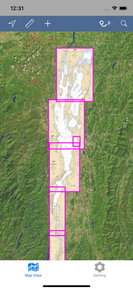
COMBINATION OF SMALL CRAFT AND HARBOR CHARTS FOR EASY NAVIGATION.
ALL CHARTS OVERLAY IS ARRANGED IN A SEAMLESS ORDER, BASED ON CHART SCALE AND PRIORITY.
NO NEED TO CHANGE CHARTS MANUALLY, THEY ARE READY FOR CONTINUOUS NAVIGATION.
CHART FEATURES:
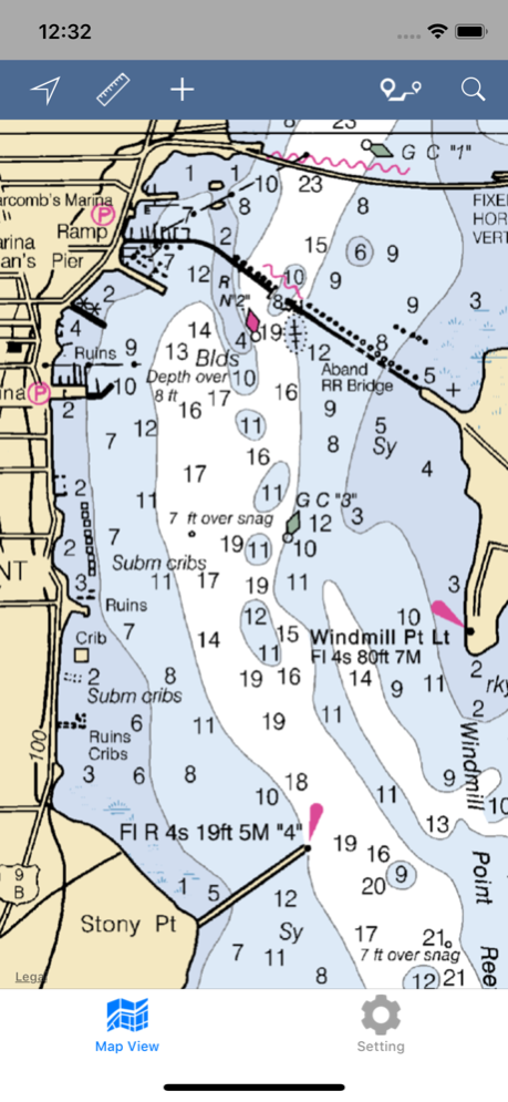
ALL MARINE RASTER NAUTICAL CHARTS ARE FROM NOAA SOURCES.
ALL CHARTS ALIGNED WITH ORIGINAL CHART CO-ORDINATES, ARE ACCURATE FOR USE.
NEW MAPS FOR OFFLINE CHART OVERLAY DISPLAY, USE THEM AS LONG AS YOU BOAT.
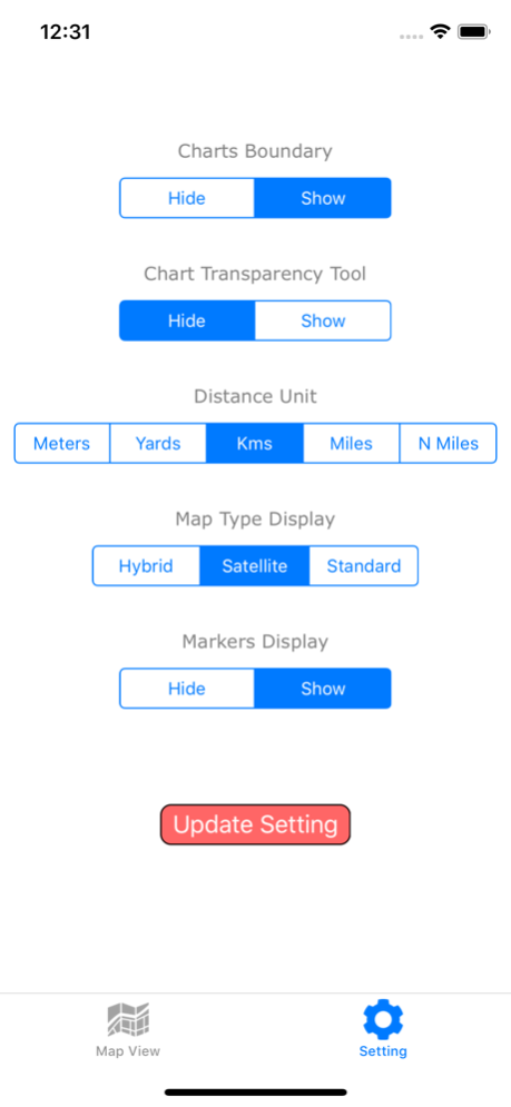
HIDE / SHOW ALL CHART BOUNDARIES.
CHART BOUNDARIES FOR EACH INSET OR SUB CHARTS ARE VISIBLE.
CHART TRANSPARENCY ADJUSTMENT TO COMPARE WITH ARIEL AND STREET MAPS.
FAVORITE MARKER:
INSERT UNLIMITED FAVORITE MARKERS ON MAP.
PHOTO TAGGED FACILITY FOR MARKERS WITH EMAIL OPTION.
ADD MULTIPLE PHOTOS TO FAVORITE MARKERS (MAX 3 ALLOWED).
EMAIL FAVORITE MARKERS AS KMZ FILE.
UPDATED FEATURES:
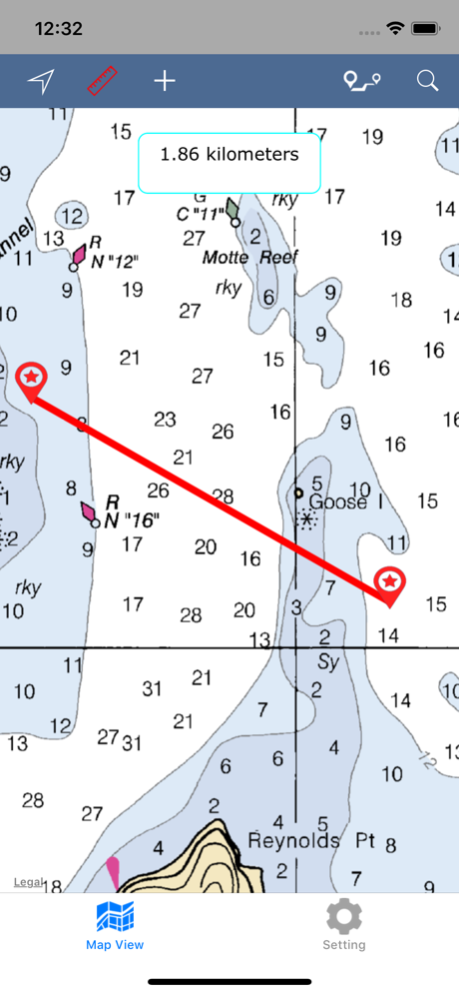
TRACK YOUR LOCATION WITH GPS ON MAP.
MEASURE LIVE DISTANCE ON CHART OVERLAY.
LONG-PRESS ON MAP TO KNOW THAT POINT CO-ODINATE & CLOSE.
MAP DIRECTIONS:
FIND REAL-TIME DRIVING DIRECTIONS (LAND BASE ONLY). GET DISTANCE, TIME DURATION & STEP BY STEP DRIVING INSTRUCTIONS.
DIRECTION INFORMATION BUTTON WILL APPEAR UNDER DIRECTION BUTTON ONCE ROUTE IS SHOWN ON MAP. CLICK IT FOR DETAILS.
INDIVIDUAL ROUTE STEP IS VISIBLE IN DIFFERENT COLOR WHEN DIRECTION STEP DETAILS ARE CLICKED.
THIS FEATURE WORKS ON NETWORK CONNECTIVITY.
MAP SEARCH:
SEARCH NEARBY POINT OF INTERESTS OF YOUR REQUIREMENT.
USER EXACT KEYWORDS FOR FAST RESULTS.
ONLY TOP RESULTS ARE SHOWN BASED ON AVAILABILITY.
THIS FEATURE WORKS ON NETWORK CONNECTIVITY.
SETTINGS:
HIDE / SHOW CHART BOUNDS.
HIDE / SHOW CHART DISPLAY (TRANSPARENCY ONLY).
MANAGE MAP DISTANCE & DIRECTION UNITS.
MAP TYPE DISPLAY UPDATION.
HIDE / SHOW MARKERS WHENEVER REQUIRED.
RUN-TIME SETTING CHANGES WILL NOT APPLY INSTANTLY FOR DIRECTIONS AND MAP DISTANCE MEASUREMENT.
THIS APP IS MOST ADVANCED WITH ALL THE NECESSARY TOOLS FOR EASY NAVIGATION ON WATER. CONTINUOUS CHARTS DISPLAY MAKES IT MORE EASIER FOR SAILING AND AS THERE WILL BE NO INTERNET WHILE SAILING, THE OFFLINE CHART MODE IS FASTER FOR NAVIGATION.
NOTE 1: All charts are Geo-positioned to match the exact location of features displayed on charts but there may be some difference between the positions of actual objects that are in the water or sea and charts because of the different chart scales.
Disclaimer: The offline Raster Nautical Charts data provided in all charts is from NOAA and is for reference purposes only and not for navigation.
We are experts in GIS & IOS Apps development and strive to provide the best products to the customers. Any suggestions from the users of this product are welcome to make the app more useful.
HAPPY BOATING AND SAILING VOYAGES ALL THE TIME!
May 27, 2018
Version 2.0
This app has been updated by Apple to display the Apple Watch app icon.
iPhone X Compatible.
iOS 11 Compatible.
Updated User-Interface for Faster use.
Add Multiple Photos to Markers (Max. 3 allowed per Marker).
Edit Marker Content and Photos any time.
Email Markers as KMZ format.
On-Land Map Points Search.
On-Land Direction Finder to Lake or between any Custom Locations.
Map Co-ordinate Info. Works on Long Press & can be Removed if not required.
Map Boundary ON/OFF adjustment.
Map Boundaries for All Loaded Charts is Visible.
Distance Measurement between 2 points.
New Map Settings updated for convenient usage.
About Lake Champlain – Boating Map
Lake Champlain – Boating Map is a paid app for iOS published in the Recreation list of apps, part of Home & Hobby.
The company that develops Lake Champlain – Boating Map is Vishwam B. The latest version released by its developer is 2.0.
To install Lake Champlain – Boating Map on your iOS device, just click the green Continue To App button above to start the installation process. The app is listed on our website since 2018-05-27 and was downloaded 19 times. We have already checked if the download link is safe, however for your own protection we recommend that you scan the downloaded app with your antivirus. Your antivirus may detect the Lake Champlain – Boating Map as malware if the download link is broken.
How to install Lake Champlain – Boating Map on your iOS device:
- Click on the Continue To App button on our website. This will redirect you to the App Store.
- Once the Lake Champlain – Boating Map is shown in the iTunes listing of your iOS device, you can start its download and installation. Tap on the GET button to the right of the app to start downloading it.
- If you are not logged-in the iOS appstore app, you'll be prompted for your your Apple ID and/or password.
- After Lake Champlain – Boating Map is downloaded, you'll see an INSTALL button to the right. Tap on it to start the actual installation of the iOS app.
- Once installation is finished you can tap on the OPEN button to start it. Its icon will also be added to your device home screen.
